Hong Kong’s Immigration Department has simplified eligibility and enrollment for the self-service immigration clearance (e-Channel) for qualifying frequent visitors. Visit their website to learn more.

Speak now


I’m Sorry. I didn’t get that.
Under the facade of metropolitan skyscrapers and concrete jungles lies a different Hong Kong with lush mountain ranges and forests. In fact, the countryside makes up three-quarters of Hong Kong's land. With the city’s highly developed transportation system, it’s easy to explore these amazing wonders of nature. Here are 10 beginner hiking routes suitable for family outings and romantic dates.
TABLE OF CONTENTS
New Territories East
- Lau Shui Heung and Hok Tau Reservoirs: Hong Kong’s ‘Mirror of the Sky’
- Bride’s Pool: breathtaking waterfalls and stone bridge architecture
- Lung Ha Wan Country Trail: a symphony of waves and galaxies
- High Island Reservoir: stunning geological formations
New Territories West
- Shing Mun River: an oasis of paperbark trees and crystal-clear waters
- Tai Mo Shan: standing atop Hong Kong’s tallest peak among the clouds
- Tai Lam Country Park: Thousand Island Lake surrounded by Sweet Gum Woods
- Ngong Ping: a scenic journey to Zen
Hong Kong Island
- Dragon’s Back: amazing views of Southern Hong Kong Island
- Pok Fu Lam to The Peak: majestic sunset atop High West
Other hiking information
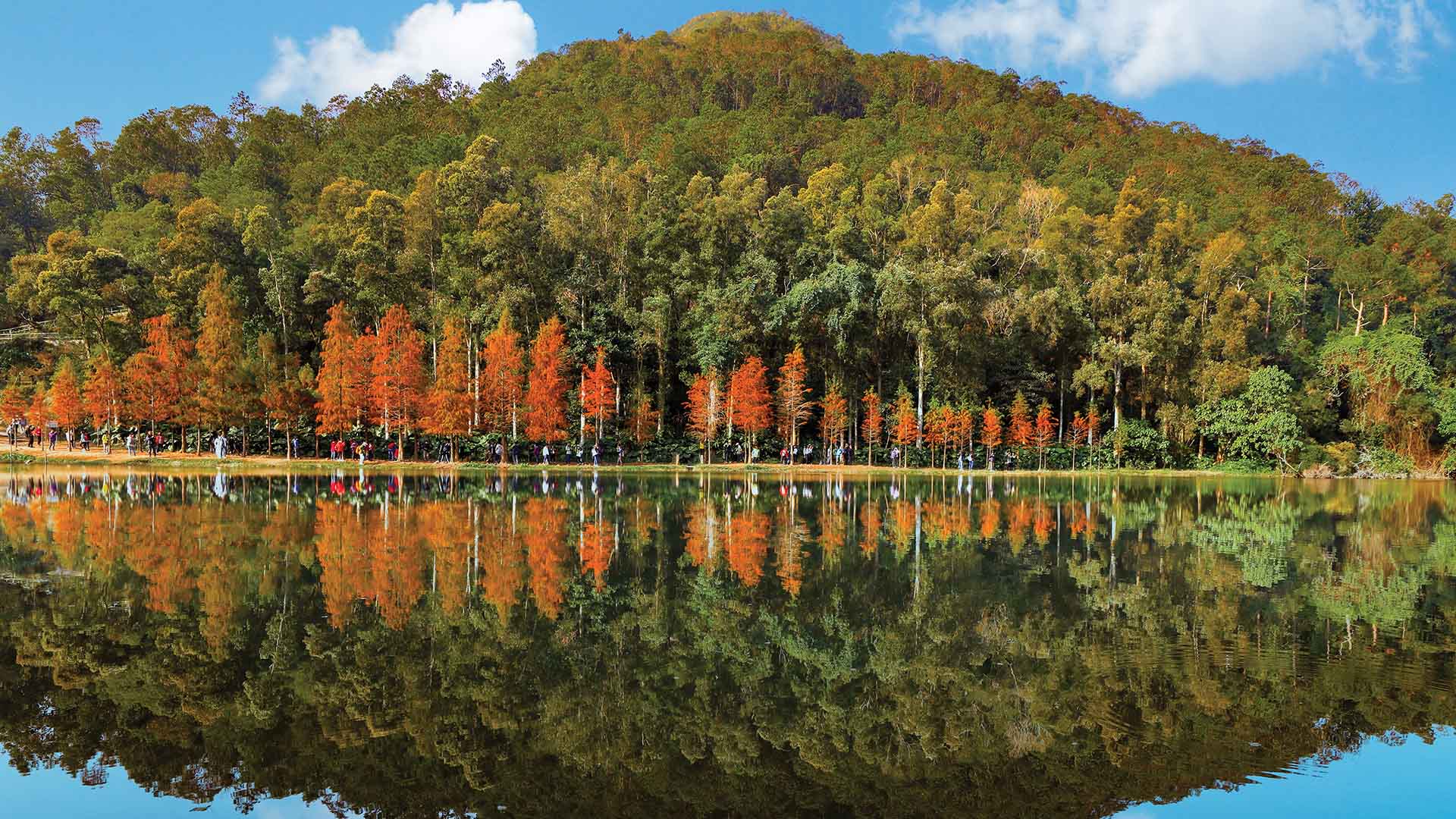
Lau Shui Heung and Hok Tau Reservoirs: Hong Kong’s ‘Mirror of the Sky’
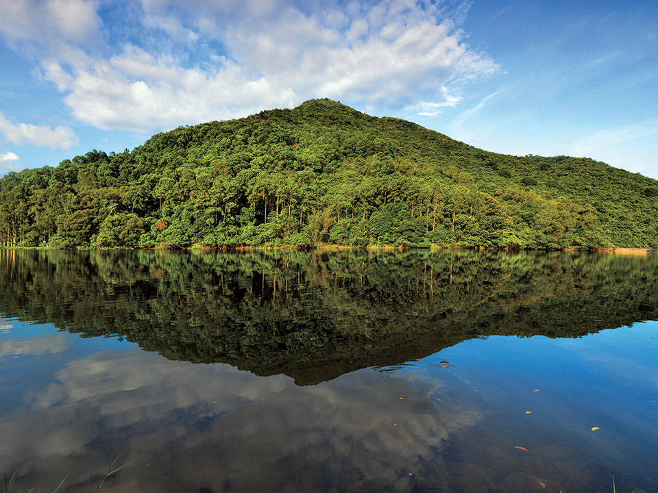
Situated in the Pat Sin Leng Country Park, this popular hiking trail passes through the wooded Fung Yuen Butterfly Reserve and Sha Lo Tung, which is home to rare species of dragonflies and damselflies. The trail ends at Lau Shui Heung Reservoir. Also known as ‘Mirror of the Sky’, the water of the reservoir perfectly reflects the lush woods and skies above on a clear day.
Lau Shui Heung and Hok Tau Reservoirs
Difficulty: Intermediate | Distance: approx. 7 km | Duration: approx. 3 hours
Route: Fung Yuen Butterfly Reserve → Sha Lo Tung → Hok Tau Reservoir → Lau Shui Heung Reservoir
Transportation: take minibus 20P from MTR Tai Po Market Station Exit A and get off at Fung Yuen Tsuen
Bride’s Pool: breathtaking waterfalls and stone bridge architecture
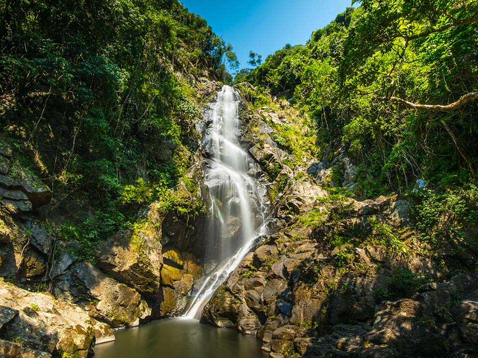
The Bride’s Pool Nature Trail encompasses the breathtaking Bride’s Pool and Mirror Pool and is an ideal family outing. Take photos of the charming stone bridge connecting the villages of Wu Kau Tang and Chung Mei, and of the majestic Mirror Pool with its plummeting torrents.
Bride’s Pool
- Difficulty: Easy | Distance: approx. 1 km | Duration: approx. 1 hour
- Route: Bride’s Pool Nature Trail → Bride’s Pool → Mirror Pool → Tai Mei Tuk
- Transportation: from MTR Tai Po Market Station Exit A3, take bus 275R to Bride’s Pool Nature Trail
Lung Ha Wan Country Trail: a symphony of waves and galaxies

The Lung Ha Wan Country Trail begins at the Lung Ha Wan Rock Carving, a historic monument with enigmatic, geometric designs that resemble animals and birds. The carving is believed to date from at least 3,000 years ago. Continue on the trail until you reach Tai Leng Tung — if you arrive at the right time, you might be able to witness the majestic sunset over High Junk Peak. The trail ends at the Tai Hang Tun Kite Flying Area, which is a fantastic place to gaze at the stars when night falls.
Clear Water Bay Country Park
- Difficulty: Intermediate | Distance: approx. 5 km | Duration: approx. 3 hours (allow enough time for stargazing)
- Route: Lung Ha Wan Rock Carving → Lung Ha Wan Country Trail → Tai Leng Tung → Tai Hang Tun Kite Flying Area
- Transportation: Take bus 91 from MTR Diamond Hill station Exit C2. Or Take minibus 103M from MTR Hang Hau Station Exit B1 and get off at Tai Au Mun.
High Island Reservoir: stunning geological formations
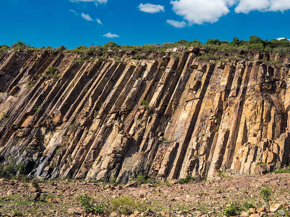
Located on High Island, the Geo Trail forms part of the MacLehose Trail, Hong Kong’s first long-distance hiking trail, which spans 100 kilometres from Sai Kung to Tuen Mun. Follow the trail to reach the peak of Biu Tsim Kok, where you’ll get a panoramic view of the idyllic Long Ke Wan. The Geo Trail also features hexagonal columnar jointings of volcanic tuff, sea caves, and sea stacks formed over the last few centuries. Sections 1, 2, and 4 of the MacLehose Trail are more challenging, but offer spectacular views of the coast.
High Island Geo Trail
- Difficulty: Easy | Distance: approx. 4.3 km | Duration: approx. 3 hours
- Route: High Island Reservoir East Dam → Biu Tsim Kok → Hexagonal Rock Columns → Fault Breccia Belt → Distorted Rock Columns → Sea Cave
- Transportation: Take bus 92 from MTR Diamond Hill Station Exit C2 to Sai Kung Town. From Sai Kung, either take minibus 9A from Pak Tam Chung, or get in a taxi to High Island Reservoir East Dam.
Shing Mun River: an oasis of paperbark trees and crystal-clear waters
A favourite hiking route for family outings, Shing Mun Reservoir offers incredible views and low levels of difficulty. Whether you take the War Relics Trail to gain a deeper understanding of Hong Kong’s history during the Second World War, or stroll along the reservoir lanes to reach the picture-perfect oasis of paperbark trees, you’ll find yourself fully relaxed surrounded by the lush greenery and birdsong.
Shing Mun Reservoir
- Difficulty: Easy | Distance: approx. 9.5 km | Duration: approx. 3 hours
- Route: Pineapple Dam Nature Trail → Paperbark Tree Corridor → Paperbark Tree Grove → Viewing Point → Main Dam → War Relics Trail
- Transportation: From MTR Tsuen Wan Station Exit B1, walk across the bridge over Castle Peak Road and through Shiu Wo Street, then take minibus 82 to the last stop, this is where the Shing Mun Reservoir Walk starts.
Tai Mo Shan: standing atop Hong Kong’s tallest peak among the clouds
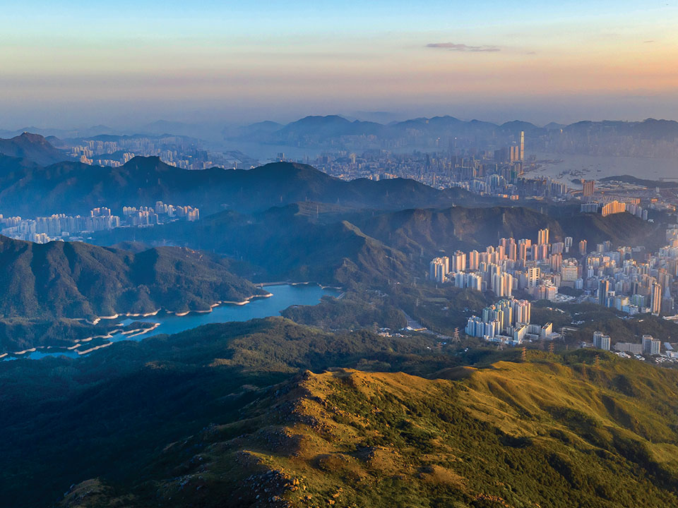
Photo Credit : Wandering Photography
Standing at an altitude of 957 metres above sea level, Tai Mo Shan is the perfect place to watch the sunset and, if conditions allow, a sea of clouds. The mountain takes on different colours through the four seasons: cherry blossoms and wild lilies bloom in spring and summer, whereas golden miscanthus thrive in autumn and winter. Although Tai Mo Shan’s summit is currently closed to the public, there are still a lot of places to camp and watch the sunset.
Tai Mo Shan
- Difficulty: Intermediate | Distance: approx. 4 km | Duration: approx. 2 hours
- Route: Rotary Park → Tai Mo Shan Country Park Visitor Centre → Tai Mo Shan Road & Tai Mo Shan Lookout → Weather Radar Station
- Transportation:, Walk to the bus stop on Tai Ho Road North from MTR Tsuen Wan Station Exit A. Take bus 51 to the Country Park stop where you’ll find the entrance on Tai Mo Shan Road.
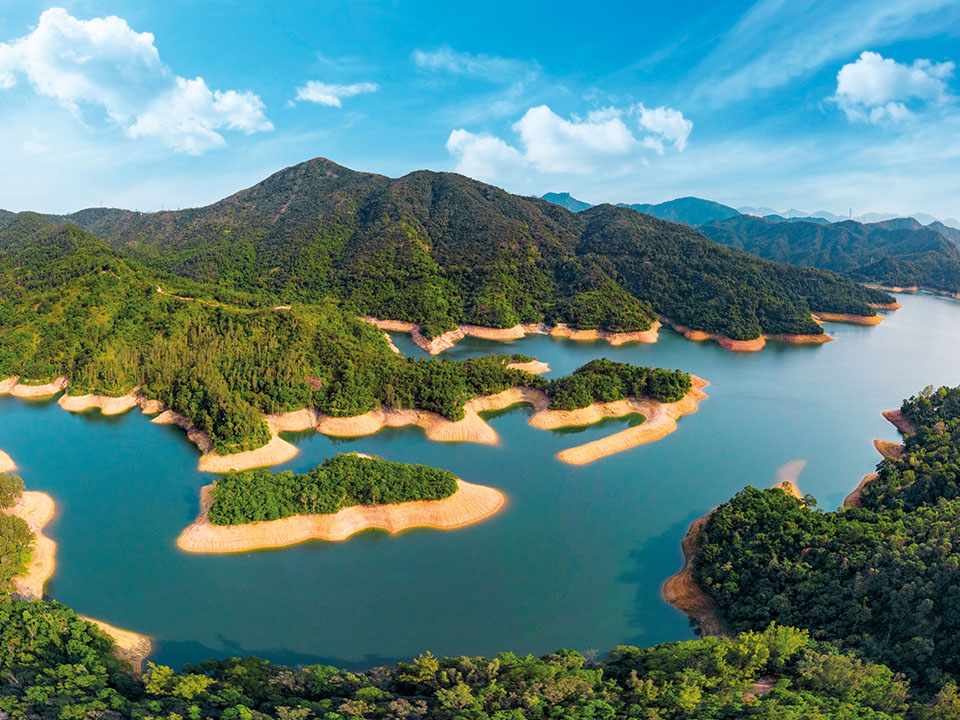
Tai Lam Country Park: Thousand Island Lake surrounded by Sweet Gum Woods
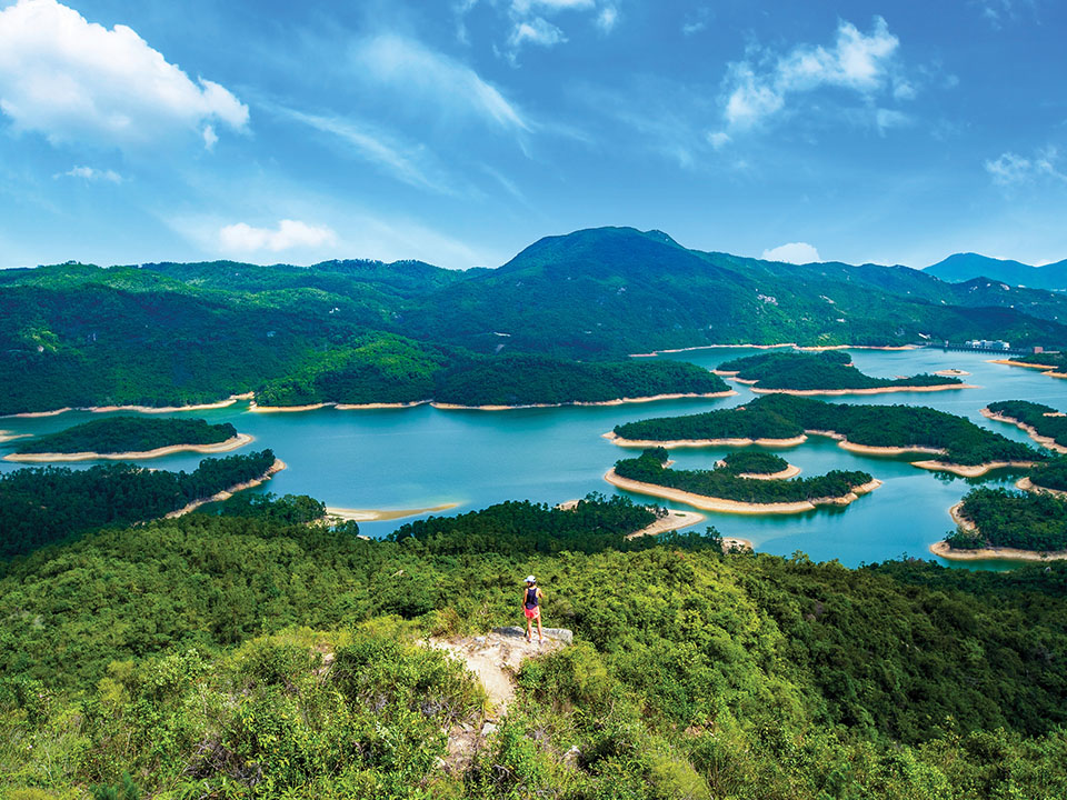
In autumn and winter, the exuberant red foliage of Sweet Gum Woods welcomes visitors to Tai Lam Country Park. What used to be a mountain lane connecting villages now leads visitors from Tai Tong, the park’s entrance, to the Reservoir Islands Viewpoint, which provides the best view of Thousand Island Lake. The dozens of small ‘islands’ in the reservoir were in fact hills before being flooded by catchwater when the reservoir was built.
Tai Lam Country Park
- Difficulty: Intermediate | Distance: approx. 11.5 km | Duration: approx. 4 hours
- Route: Tam Lam Country Park → Tai Tong Sweetgum Woods → Reservoir Islands Viewpoint → Tai Lam Chung Reservoir → Golden Beach
- Transportation: Take bus K66 from Long Ping Station Exit B2. Get off at the bus stop on Tai Tong Shan Road, and walk 30 minutes to the Tai Lam Country Park entrance.
Ngong Ping: a scenic journey to Zen
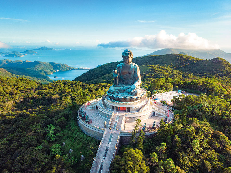
Ngong Ping is a beautiful plateau on Lantau Peak with Buddhist establishments including Po Lin Monastery, the Tian Tan Buddha and Wisdom Path. As you hike through Shek Pik Reservoir, you’ll find spiral squares and circle-like rock carvings estimated to have existed for three millennia. You’ll also see the Hong Kong International Airport and the Hong Kong-Zhuhai-Macao Bridge, among other amazing panoramic views.
Ngong Ping
- Difficulty: Intermediate | Distance: approx. 14 km | Duration: 5.5 hours
- Route: Po Lin Monastery & Tian Tan Buddha → Dong Shan Fa Mun & the Nei Lak Shan Country Trail → Wisdom Path → Shek Pik Reservoir
- Transportation:
- Route 1 – Head to the Tung Chung Cable Car Terminal from MTR Tung Chung Station Exit B for a cable car ride to Ngong Ping.
- Route 2 – Head to the bus terminus from MTR Tung Chung Station Exit B, take Lantau Bus 23 to the Ngong Ping Bus Terminus.
- Route 3 – Take First Ferry from Central Pier 6 to Mui Woo, and then take Lantau Bus 2 to Ngong Ping Bus Terminus.
- Route 1 – Head to the Tung Chung Cable Car Terminal from MTR Tung Chung Station Exit B for a cable car ride to Ngong Ping.
Read more: Ngong Ping: a spiritual hike
Dragon’s Back: amazing views of Southern Hong Kong Island
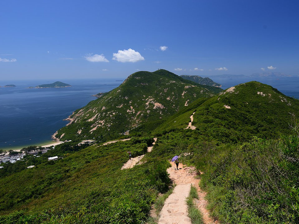
Photo Credit : Joe Chen
Deemed one of the best hikes in Hong Kong by Lonely Planet, Dragon’s Back got its name from its undulating ridge that resembles a dragon’s backbone. The ridge slopes steeply down to sea level, revealing stunning views of the ocean and nearby isles. The trail ends at Big Wave Bay Beach, which makes a great spot for sunbathing and taking a dip in the cooling sea in the summer.
Dragon’s Back
- Difficulty: Intermediate | Distance: approx. 8.5 km | Duration: 4 hours
- Route: Shek O Peninsula Viewing Point → Shek O Peak → Dragon’s Back & Pottinger Gap → Big Wave Bay
- Transportation: From MTR Shau Kei Wan Station Exit A3, walk to the Shau Kei Wan Bus Terminus. Take bus 9 or the red minibus with the sign “Shek O” to the To Tei Wan stop on Shek O Road.
Pok Fu Lam to The Peak: majestic sunset atop High West
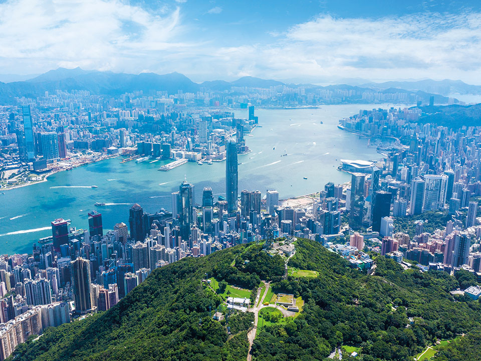
The route starts off with a gentle hike from Pok Fu Lam Country Park and passes through Pok Fu Lam Reservoir. It won’t be long before you reach The Peak, where modern architecture meets historical sites. Against the lush greenery of the Lugard Road loop, Hong Kong’s urban skyline stands out magnificently. If you want to see the sunset, hike up to High West.
Pok Fu Lam to The Peak (High West)
- Difficulty: Easy | Distance: approx. 6 km | Duration: approx. 2.5 hours
- Route: Pok Fu Lam Reservoir → Lugard Road → The Peak Tower → High West
- Transportation: Take bus 4X, 7, 30X or 91 from the Central (Exchange Square) Bus Terminus and get off at Pok Fu Lam Reservoir Road
Read more: Pok Fu Lam to the Peak: taking it to the top
Useful hiking tips
You should always be well-prepared for hikes regardless of the difficulty of the trail, and remember the five ‘Don’ts’ when hiking: don’t hike alone, don’t take shortcuts, don’t litter, don’t damage the environment, and don’t start fires randomly. Find more tips on hiking here.
In case of an emergency, dial 112 or 999 or use the nearest emergency phone. Provide the operator with the nearest distance post number (e.g., M001).
Recommendations for advanced routes
If you are looking for something a bit more challenging, we recommend the following trails: